Emergency Rescue
Smart Helmet Solution
Real-time field visibility, responder coordination, voice communication, and command-center collaboration for time-critical rescue operations.
HelmetSight helps rescue organizations improve field awareness, team coordination, incident response speed, and post-mission traceability by combining smart helmet terminals with a visual command platform. The solution enables command centers to see what responders see, communicate directly with field teams, track responder locations in real time, respond to emergency alerts, and review incident evidence for operational improvement and accountability.
Suitable for Multiple Emergency Rescue Scenarios
This solution is designed for mountain rescue, flood response, typhoon/storm emergency response, earthquake/collapsed-building search, wildfire/forest emergency operations, event emergency standby and public safety support, emergency drills and command exercises. The system is also adaptable for rescue teams with different organizational workflows and visual identity requirements.
Why Emergency Rescue Teams Need a Different Helmet System
Fragmented Field Information
Command centers receive scattered radio reports without visual confirmation. Critical scene details are lost in verbal descriptions, leading to delayed or inaccurate decision-making during high-stakes operations.
Command Center Cannot See the Real Scene
Without first-person video from responders, command teams must rely on incomplete information. This delays situational assessment, resource allocation, and tactical adjustments in rapidly evolving rescue environments.
Responders Operating in Dispersed Terrain
Rescue teams often split across wide areas--mountain slopes, flooded zones, collapsed structures. Coordinating multiple units without real-time location awareness creates confusion and increases response time.
Difficulty Locating Team Members in Real Time
In dense forests, urban ruins, or night operations, knowing where each responder is located is critical. Manual check-ins are slow and unreliable, especially when communication channels are congested.
Delayed Escalation When Responder in Distress
If a responder falls, becomes trapped, or loses consciousness, manual SOS activation may not be possible. Automatic distress detection and immediate alert routing to command can save critical minutes.
Limited Voice Coordination in Noisy Environments
Radios can fail in extreme weather or high-noise zones. Group intercom and broadcast functions integrated into helmets ensure reliable team communication even when traditional channels are compromised.
Poor Evidence Capture and Post-Incident Review
Without recorded video and audio from the field, post-mission analysis is difficult. Evidence gaps hinder training improvement, accountability, and legal or insurance documentation.
Inconsistent Data Handoff Between Field and Command
Manual data transfer--photos sent via phone, verbal reports logged by hand--introduces errors and delays. Automated data upload from helmet to platform ensures consistent, timestamped records.
Need for Controlled Zone Management
Rescue operations often involve hazardous zones that responders should not enter without authorization. Electronic fence / geofencing capabilities alert command when a responder crosses defined boundaries.
What the Solution Includes
A complete system combining field terminals, command platform, and flexible deployment options.
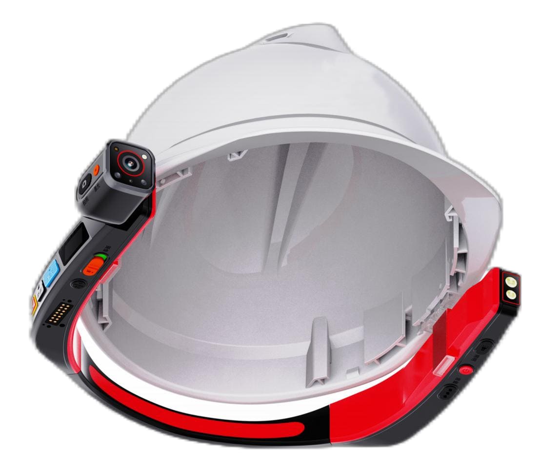
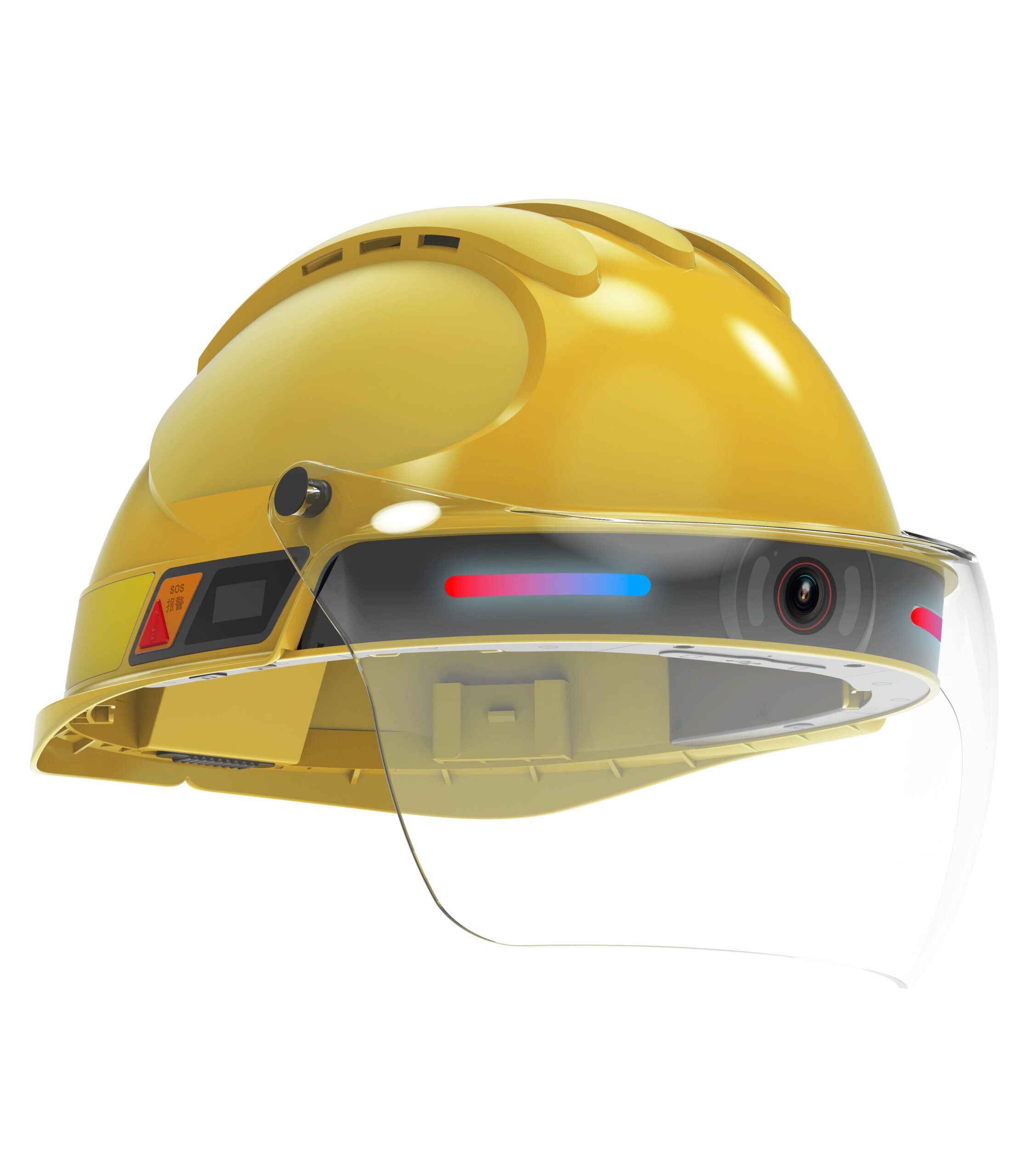
Smart Helmet Terminal
Field-worn device that captures first-person video and audio, enables two-way voice communication, tracks responder location, and triggers emergency alerts. Designed for ruggedized field use in rescue operations.
Command Platform
PC dashboard and mobile APP providing command centers with real-time field visibility, alarm management, responder coordination, playback review, and operational oversight. Built around field-device data collection and command-side decision support.
Deployment / Integration
Flexible deployment options to match organizational requirements, data residency policies, and existing system integration needs. Choose the model that fits your operational and technical environment.
How It Works in a Rescue Operation
A step-by-step view of how smart helmets and command platform work together during emergency response.
Incident Activation
Emergency call received. Command center activates operation in platform, assigns responders, defines mission parameters, and sets electronic fence boundaries if needed. Responders power on smart helmets and confirm readiness status.
Team Deployment
Rescue teams move to field locations. Helmets begin transmitting GPS location data to command platform. Command center monitors team movement on map view, confirms positioning accuracy, and verifies communication channel connectivity before field engagement.
Field Audio/Video & Location Feedback
Responders enter rescue zone. Smart helmets capture first-person video and audio, streaming live to command center. Command teams see what responders see, assess scene conditions in real time, identify hazards, locate victims, and update tactical plans based on visual confirmation.
Command Coordination & Remote Instruction
Command center uses two-way voice and broadcast functions to coordinate multiple units, provide real-time guidance, redirect teams based on new information, and allocate resources dynamically. Group intercom enables team-to-team communication without command center relay when needed.
Alarm / SOS / Responder Safety Management
If a responder triggers SOS, falls, or becomes inactive for a configured period, automatic alarm is sent to command platform with location and last-known video frame. Command immediately dispatches backup team, communicates with affected responder if possible, and monitors situation until resolution.
Playback, Evidence Retention & After-Action Review
After operation concludes, command center reviews recorded video, audio, location tracks, and alarm events. Data is stored for training, accountability, legal documentation, and operational improvement. Teams analyze response time, decision points, and areas for protocol enhancement.
Core Capabilities for Emergency Rescue
Comprehensive features designed specifically for rescue operation requirements.
Real-Time Field Visibility
Command centers see live first-person video from each responder, enabling immediate situational assessment without relying on verbal descriptions. Critical for fast decision-making in dynamic rescue environments.
Responder Voice Coordination
Two-way voice communication, group intercom, and broadcast functions integrated into helmets ensure reliable team coordination even in noisy or wide-area environments where traditional radio channels may be compromised.
One-Touch Emergency Escalation
Responders can trigger SOS alerts instantly. Automatic man-down detection sends alerts if a responder falls or becomes inactive. Immediate notification to command center with location and last video frame enables rapid backup deployment.
Location-Based Responder Awareness
GPS positioning tracks each responder in real time on command platform map. Enables coordinated multi-unit operations, prevents team overlap, and ensures command knows exactly where each responder is located at all times.
Route & Movement Trace Review
Platform records complete movement paths with timestamps. Command can replay responder routes to understand search patterns, identify coverage gaps, and optimize future operations. Essential for large-area search missions.
Incident Playback & Evidence Retention
All video, audio, location, and alarm data is recorded and stored. Command teams can review operations for training, accountability, legal documentation, and operational improvement. Timestamped evidence supports post-incident analysis.
Electronic Fence for Controlled Zones
Define hazardous or restricted zones on platform map. Geofencing alerts command when a responder crosses defined boundaries, enabling proactive safety management and preventing unauthorized entry into dangerous areas.
Prolonged Inactivity Alert Logic
Configurable motion detection monitors responder activity. If no movement detected for a defined period, automatic alert sent to command. Helps identify trapped, injured, or incapacitated responders who cannot manually trigger SOS.
Remote Command Collaboration
Platform enables command staff to collaborate remotely via PC and mobile APP. Multiple command personnel can monitor operations simultaneously, coordinate resource allocation, and provide real-time guidance to field teams.
Customizable Rescue-Team Identity
Helmets can be customized with team logo, team name, shell color, rear numbering, and reflective markings. Supports organizational branding and visual identification in multi-agency operations or public-facing rescue missions.
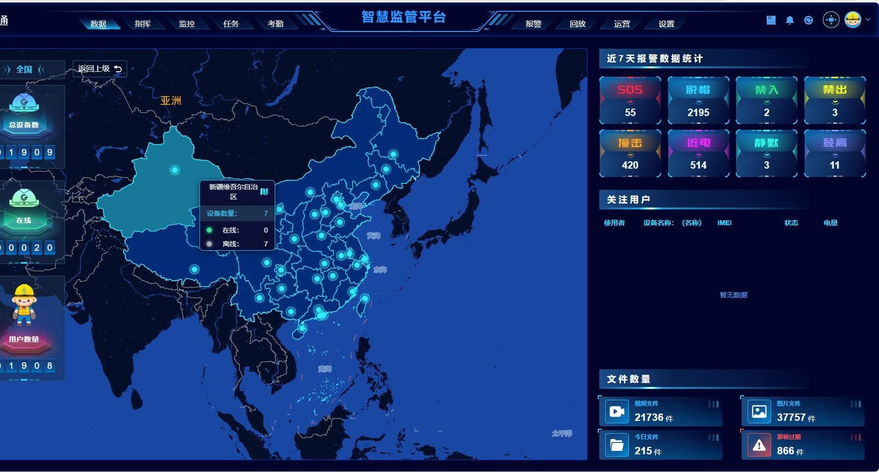
Platform Snapshot for Command Centers
A practical command and supervision system built around field-device data collection and command-side decision support. The platform provides command teams with the tools needed to manage rescue operations effectively.
Data Home / Operational Overview
Dashboard showing active operations, total responders deployed, device status, recent alarms, and key metrics. Provides command teams with a consolidated view of all ongoing rescue activities at a glance.
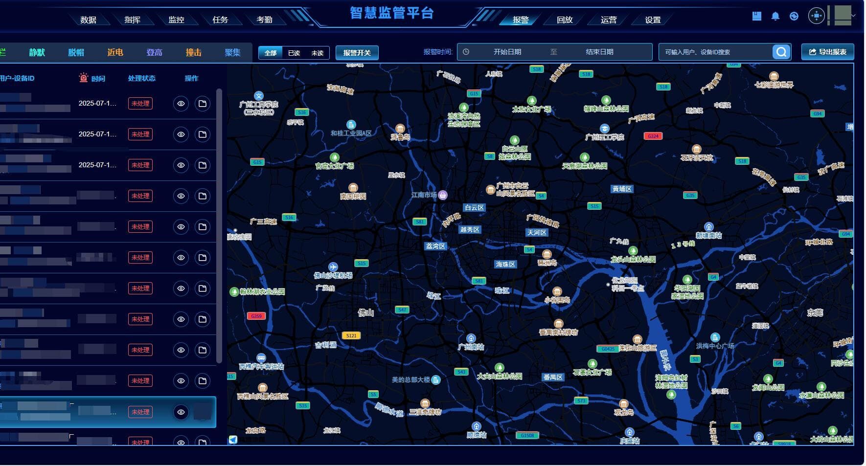
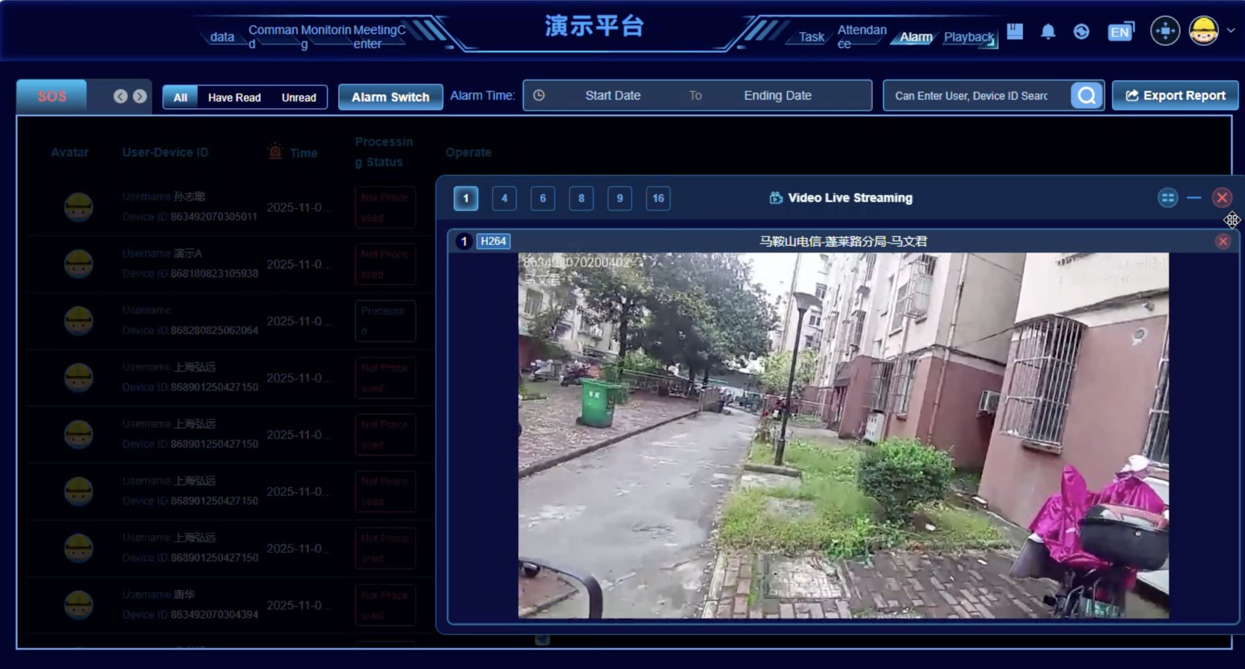
Alarm Center
Centralized alarm management for SOS triggers, man-down alerts, geofence breaches, and prolonged inactivity events. Each alarm includes responder ID, location, timestamp, and last video frame. Command can acknowledge, escalate, or dispatch backup directly from alarm interface.
Command Center
Voice communication hub for remote instruction, broadcast, and team coordination. Command personnel can initiate two-way calls with individual responders, send broadcast messages to all field units, or facilitate group intercom sessions between teams.
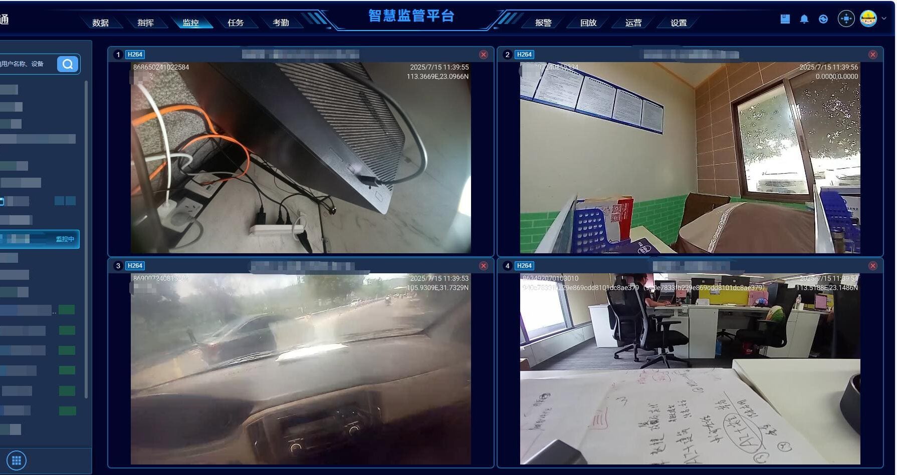
Monitoring Center
Real-time video monitoring interface showing live streams from all active helmets. Command can view multiple feeds simultaneously, switch between responders, and zoom in on specific operations. Map view displays responder locations with status indicators.
Playback Center
Review recorded video, audio, and location tracks from past operations. Search by responder, time range, or event type. Playback includes synchronized video, audio, location map, and alarm events. Export clips for training or documentation.
Attendance / Personnel Visibility
Track responder deployment status, shift schedules, and operational hours. Relevant for projects requiring personnel management and operational accountability. Can be configured based on organizational workflow requirements.
Operation / Task Center
Create, assign, and track rescue missions. Define operation parameters, assign responders, set geofence boundaries, and monitor task completion. Supports structured mission planning and resource allocation for complex multi-team operations.
Role-Based Management
Configure user roles and permissions depending on deployment model and organizational structure. Define who can view live video, trigger alarms, access playback, or manage responder assignments. Supports multi-level command hierarchies.
Typical Rescue Scenarios
How smart helmets and command platform address operational challenges across different emergency response environments.
Mountain Rescue
Rescue teams operate across steep, forested terrain with limited visibility and unreliable radio coverage. Command center cannot see terrain conditions, victim location, or team progress. Manual position reports are slow and inaccurate.
Real-time location tracking to coordinate multiple search units, first-person video to assess terrain hazards and victim condition, reliable voice communication in noisy mountain environments, and automatic alerts if a responder falls or becomes trapped.
Smart helmets provide GPS tracking so command can see each responder's location and movement path on map. First-person video lets command assess terrain, identify victim location, and guide responders remotely. Group intercom ensures reliable team communication. Man-down alerts trigger immediately if a responder falls.
Full situational awareness without being on-site. Can coordinate multiple teams efficiently, redirect resources based on visual confirmation, identify hazards before responders encounter them, and maintain complete operational record for post-mission review and training improvement.
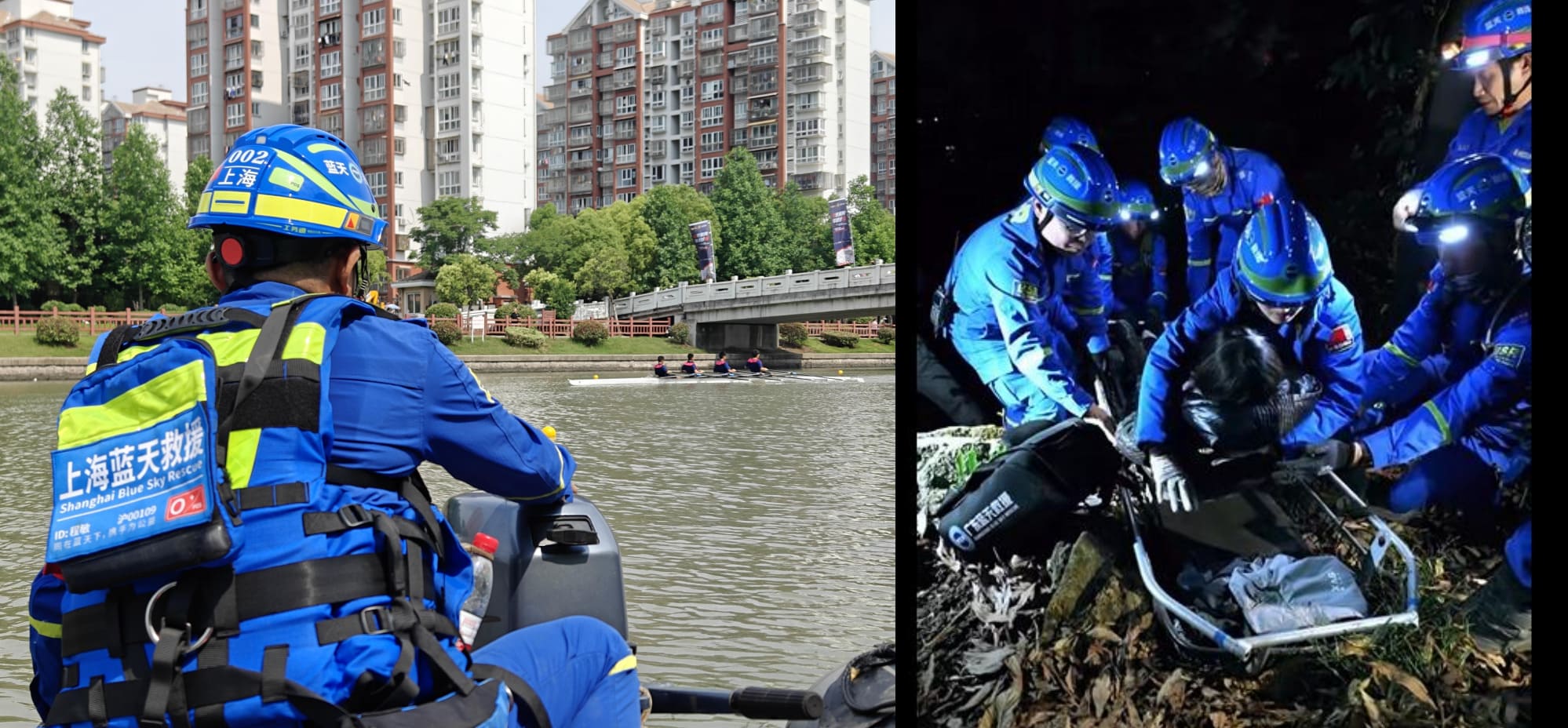
Flood / Water Rescue
Rapidly changing water levels, submerged obstacles, and wide search areas make coordination difficult. Responders in boats or wading through floodwater face communication challenges and safety risks. Command needs to know water depth, flow speed, and safe access routes.
Waterproof communication devices, real-time location tracking to prevent responders from entering dangerous zones, first-person video to show water conditions and victim locations, and automatic distress alerts if a responder is swept away or capsized.
IP67 waterproof helmets function in wet conditions. GPS tracking with geofencing prevents responders from entering high-risk zones. Live video shows water depth, flow speed, and obstacles to command. SOS and man-down alerts trigger immediately if responder is in distress. Voice communication remains functional even in noisy flood environments.
Visual confirmation of water conditions without sending additional personnel. Can define safe zones and alert responders approaching danger. Coordinates boat teams and ground teams simultaneously using map view. Reviews video evidence to improve future flood response protocols.
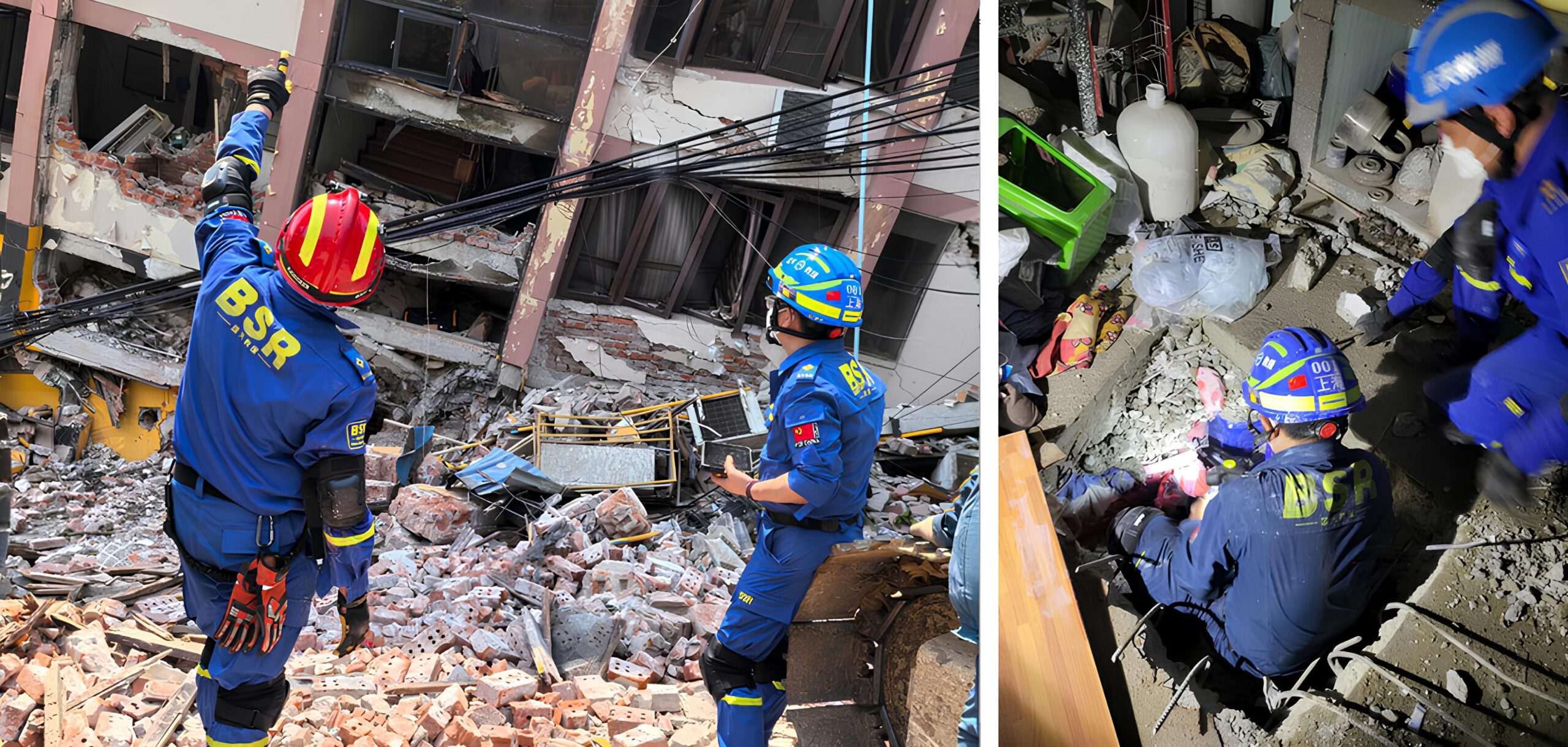
Earthquake / Collapsed-Structure Response
Responders enter unstable buildings with risk of secondary collapse. Visibility is poor due to dust and debris. Radio signals may be blocked by concrete and rebar. Command needs to know structural stability, responder location inside buildings, and victim status.
Hands-free communication while moving through debris, first-person video to show structural hazards and victim locations, location tracking so command knows which floor or room responders are in, and immediate alerts if building shifts or responder is trapped.
Helmet-mounted camera captures structural conditions and victim locations without requiring responders to hold a device. GPS tracking (where signal permits) and movement logging help command track responder progress through building. Voice intercom allows coordination between teams inside and outside structure. SOS trigger and inactivity alerts provide safety net if responder is trapped by secondary collapse.
Real-time assessment of structural stability from first-person view. Can advise responders to evacuate if building shows signs of further collapse. Coordinates entry and exit routes based on visual evidence. Records entire operation for structural engineers and future training.
Typhoon / Severe Weather Emergency Response
High winds, heavy rain, and flying debris create extreme operational hazards. Traditional communication devices fail in wet conditions. Visibility is near zero. Command cannot assess weather impact on field operations without visual confirmation.
Weather-resistant communication and recording devices, hands-free operation to navigate hazardous conditions, real-time video to show wind damage and evacuation routes, and location tracking to ensure no responder is left in dangerous zones.
IP67 waterproof helmets continue functioning in heavy rain and wind. First-person video shows actual storm impact--downed power lines, blocked roads, structural damage--enabling command to reroute teams safely. GPS tracking ensures command knows where each responder is during rapidly changing conditions. Voice intercom remains functional when radio channels are overloaded.
Real-time weather impact assessment from multiple field locations. Can prioritize rescue areas based on visual severity. Coordinates evacuation routes using video evidence of road conditions. Records storm damage for disaster assessment and insurance claims.
Emergency Drill / Multi-Agency Command Exercise
Training exercises and command drills need realistic data collection to evaluate team performance, identify protocol gaps, and improve coordination. Manual observation is incomplete and subjective. Post-drill analysis lacks objective evidence.
Complete recording of drill activities, accurate timing of response actions, objective assessment of communication effectiveness, and detailed playback for after-action review and training improvement.
Smart helmets record first-person video, audio, and location data throughout entire drill. Command platform logs all communication, alarms, and coordination actions with timestamps. Multiple agencies can observe drill in real time from command center. Complete data set enables objective performance evaluation.
Comprehensive drill documentation for training analysis. Can review decision points, response times, and coordination effectiveness frame-by-frame. Identifies protocol weaknesses and training gaps with objective evidence. Shares video clips with teams for targeted improvement. Builds library of training scenarios for future exercises.
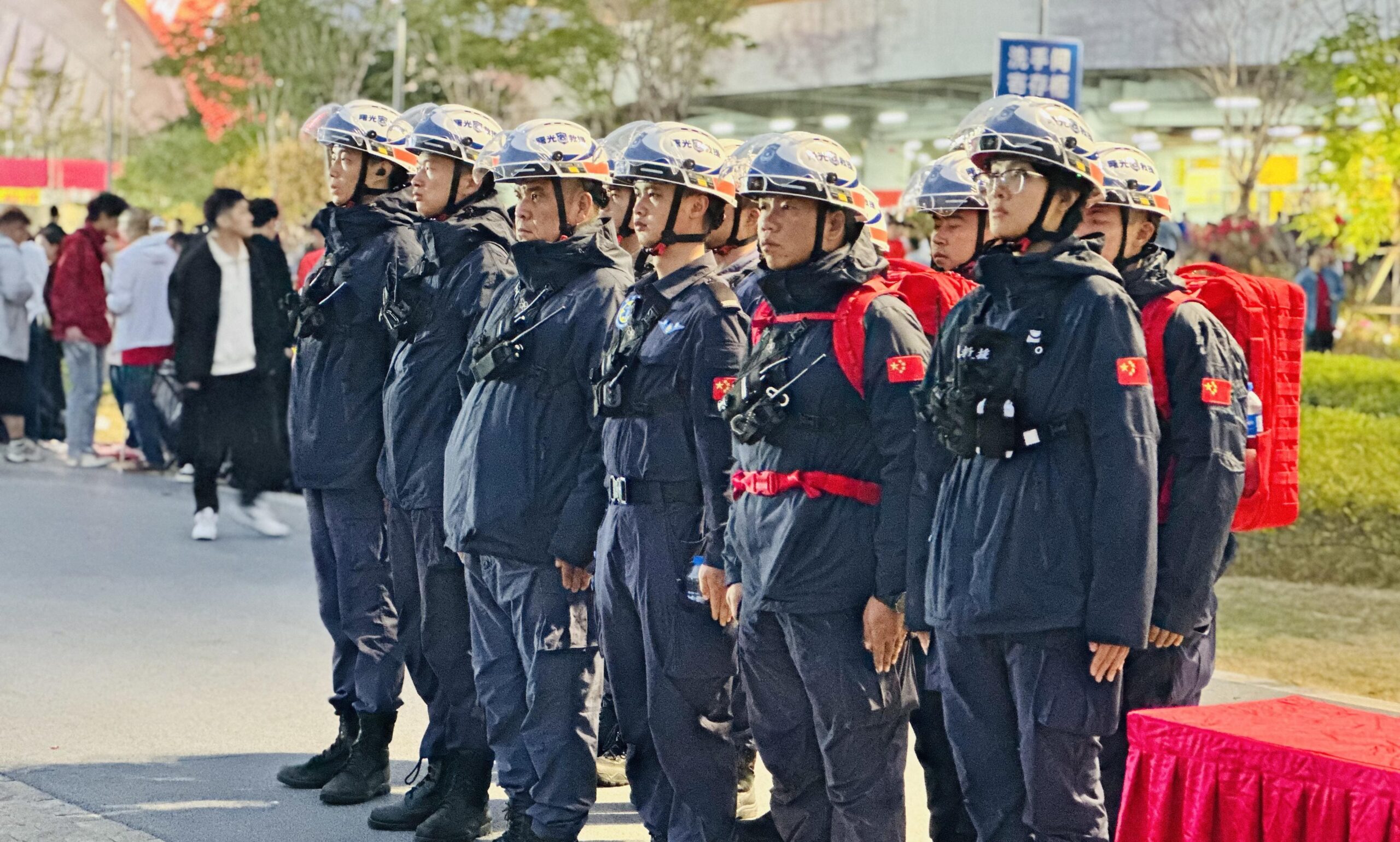
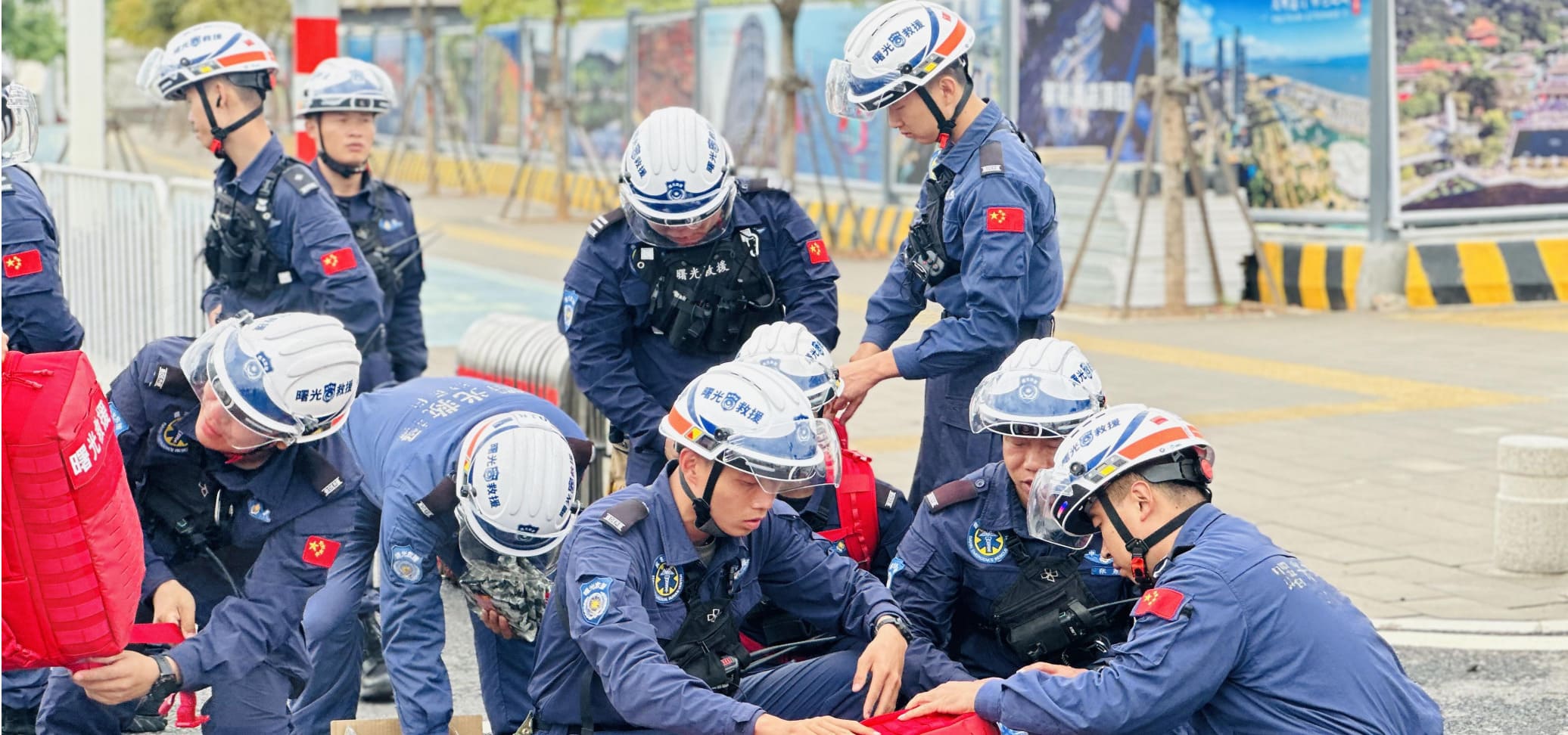
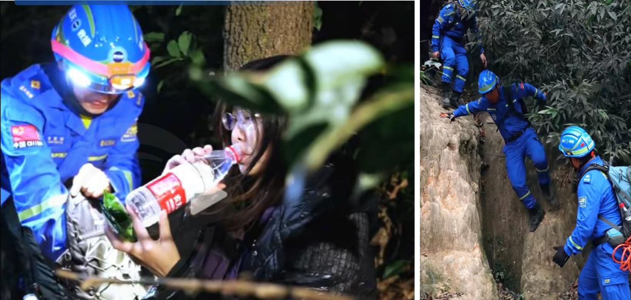
Field Application References
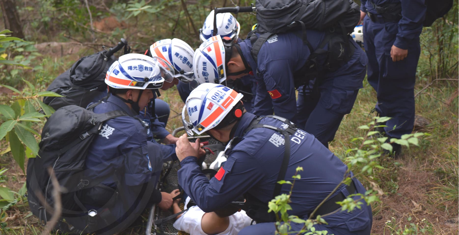
Typical application references from the project materials include rescue team field deployments, emergency response operations, command center drills, and customized rescue helmet identity implementations. These examples represent the types of deployments supported by HelmetSight smart helmet solution.
Mountain Rescue Team Deployment
Field deployment references include mountain rescue operations with GPS tracking, first-person video capture, and command center coordination across dispersed terrain.
Earthquake Response Examples
Example deployments in collapsed-structure search operations with real-time video assessment, responder location tracking, and command-side coordination.
Water Rescue / Night Operations
Field references indicate water rescue deployments with waterproof helmets, geofencing for safety zones, and night operation support where configured.
Typhoon Emergency Response
Typical application references include severe weather response with IP67 waterproof operation, real-time storm impact assessment, and evacuation coordination.
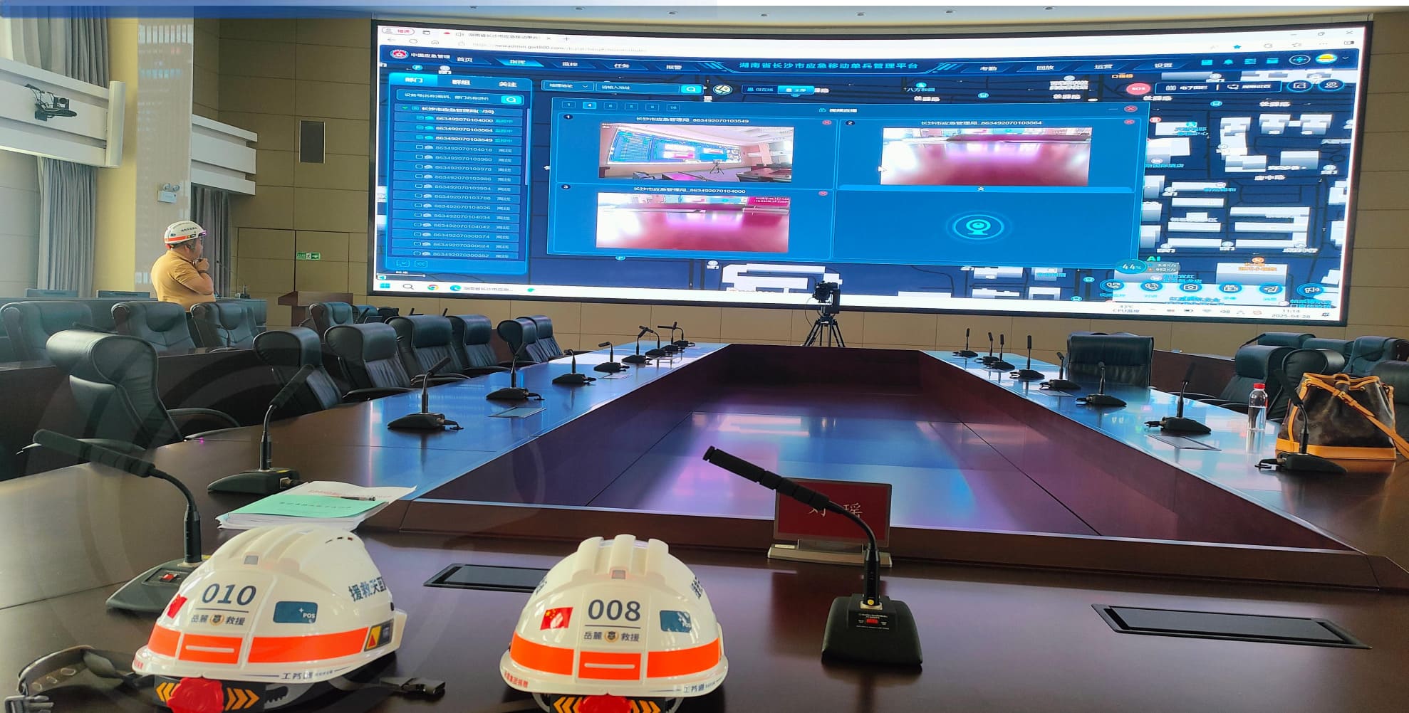
Command Center Drill & Dispatch
Example deployment types include emergency drills with complete video/audio recording, multi-agency coordination, and after-action review capabilities.
Customized Rescue Helmet Identity
Field references show customized helmet implementations with team logos, color schemes, rear numbering, and reflective markings for rescue team branding.
Note: The examples shown represent typical deployment types and application scenarios supported by HelmetSight smart helmet solution. Actual project configurations, functional modules, platform deployment models, and customization options vary based on organizational requirements and project scope. Contact our engineering team to discuss specific application needs and deployment planning.
Customization for Rescue Organizations
Practical customization options to match organizational identity, operational requirements, and deployment preferences.
Visual Identity Customization
Helmet shell can be produced in custom colors to match organizational branding or operational requirements. Suitable for teams needing visual distinction between units or agencies.
Organization logo and team name can be printed or applied to helmet surface. Supports rescue team identity management and public recognition during operations.
Individual responder numbers or ID codes can be added to helmet rear for easy identification in command center video feeds and field coordination.
Reflective tape or markings can be applied for night operations and high-visibility requirements. Positioning and pattern configurable based on project needs.
Functional & Deployment Customization
Depending on project scope, functional modules can be configured to match operational requirements. For example, some projects may prioritize video recording, others may focus on location tracking and alarms.
Organizations can choose SaaS cloud subscription (1-year free), on-premise private deployment, or API/SDK integration depending on data residency policies and technical environment.
Helmets can connect to command platform via 4G LTE, WiFi (where available), or other network configurations depending on project deployment environment and connectivity requirements.
Platform user roles, permissions, and organizational hierarchy can be configured to match command structure. Supports multi-level management and role-based access control depending on project needs.
Customization scope and options are defined during project evaluation and procurement planning. Contact our engineering team to discuss specific organizational requirements, technical constraints, and customization feasibility for your deployment.
Discuss Customization OptionsFlexible Deployment Options
Choose the deployment model that fits your organizational requirements, data residency policies, and technical environment.
Cloud Subscription
Quick activation with 1-year free cloud subscription. Ideal for rescue teams that want immediate deployment without infrastructure setup. Managed hosting, automatic updates, and technical support included.
On-Premise Deployment
Paid private or local deployment for organizations with strict data control, network isolation, or regulatory compliance requirements. Full control over data storage, access, and security policies.
API & SDK Integration
Integration to customer's existing platform for projects needing deeper customization, data interoperability, or unified command systems. Scope-defined development and protocol integration available.
Related Products
Organizations can choose integrated helmet or retrofit-oriented architecture depending on project preference and existing equipment inventory.
G808 Smart Safety Helmet
All-in-one hard hat with integrated 4G communication, video/voice capabilities, GPS positioning, and comprehensive safety alarm systems. Complete solution for rescue teams starting new deployments or replacing existing equipment.
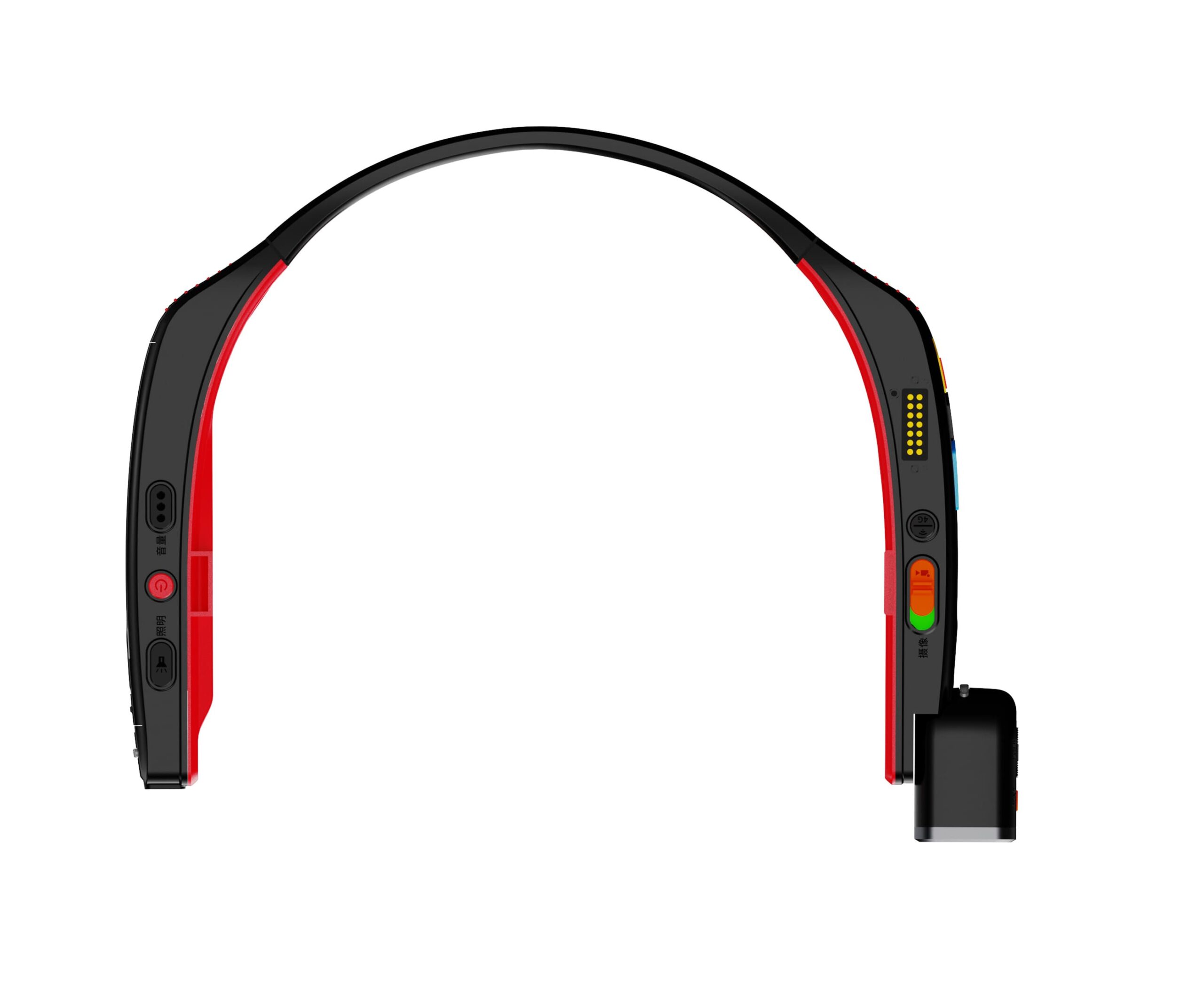
G901 Helmet-Mounted Recorder
Attachable recorder that upgrades standard hard hats to smart safety helmets. Ideal for organizations that want to keep existing helmet inventory while adding smart monitoring, video capture, and communication capabilities.
Technical & Procurement FAQ
Can the solution support live field video and voice communication?
Yes. Smart helmets capture first-person video and audio, streaming live to command platform via 4G LTE. Two-way voice communication, group intercom, and broadcast functions are integrated. Command centers can see what responders see in real time and communicate directly with field teams. Video quality and streaming latency depend on network conditions.
Can command teams see responder locations in real time?
Yes. GPS positioning tracks each responder's location continuously. Command platform displays responder positions on map view with status indicators. Location data is logged for route playback and analysis. Geofencing / electronic fence features allow command to define controlled zones and receive alerts when responders cross boundaries.
Is the platform available as SaaS or on-premise?
Both. Organizations can choose cloud subscription (1-year free, then subscription-based) for quick activation, or paid on-premise deployment for data residency and network isolation requirements. API/SDK integration is also available for projects needing custom platform connection. Deployment model is selected during project planning based on organizational policies and technical environment.
Can the helmet appearance be customized for rescue teams?
Yes. Helmet shell color, team logo, team name, rear numbering, and reflective markings can be customized to match organizational branding and operational requirements. Customization scope is defined during procurement planning. Minimum order quantities and lead times apply for custom production.
Does the solution support incident playback and evidence review?
Yes. All video, audio, location, and alarm data is recorded and stored (cloud or on-premise depending on deployment model). Platform playback center allows command teams to review operations by responder, time range, or event type. Playback includes synchronized video, audio, location map, and alarm events. Video clips can be exported for training, documentation, or legal purposes.
Can the system be integrated with an existing platform?
Yes. API/SDK integration is available for projects requiring connection to existing command systems, emergency management platforms, or data warehouses. Integration scope, protocol requirements, and development effort are defined during technical evaluation. Custom development is quoted separately based on project requirements.
Is the solution suitable for mountain, flood, and disaster-response environments?
Yes. Smart helmets are designed for ruggedized field use with IP67 waterproof rating, impact-resistant construction, and operational temperature range suitable for most rescue environments. GPS positioning works in outdoor operations. Video streaming requires 4G LTE network coverage. Battery runtime is approximately 12 hours depending on usage. Specific environmental requirements should be discussed during project evaluation.
What is included in the 1-year free cloud subscription?
1-year free cloud subscription includes platform access for defined number of user accounts, cloud storage for video/audio/location data (storage quota defined in project scope), real-time video streaming, alarm management, playback review, and basic technical support. After 1 year, subscription renewal is required to continue cloud service. On-premise deployment does not include free cloud period but provides perpetual platform license.
Explore Related Resources
Learn more about the products, platform, and deployment options that support this solution.
Back to Solutions
Return to the main solution overview page to explore other application scenarios.
G808 Smart Safety Helmet
See the integrated smart helmet solution with video, voice communication, GPS tracking, and safety alerts.
G901 Helmet-mounted Recorder
Explore the retrofit option for existing helmets.
Monitoring Platform
Understand how dashboards, alerts, playback, and role-based management support field operations.
Deployment Options
Compare cloud subscription, on-premise deployment, and API / SDK integration.
Need help with this application?
Our engineering team is ready to discuss your specific requirements and deployment scenarios.
Contact an Engineer
Build a More Visible and
Better Coordinated Rescue Operation
We invite rescue organizations, emergency departments, system integrators, and project teams to discuss deployment planning, platform deployment models, customization options, and project evaluation. Our engineering team is available to answer technical questions and provide project quotations.